Traffic Comparison in Hampton Roads
- Adam Garrett
- Apr 4, 2023
- 1 min read
Updated: Feb 14, 2024

Most images including above courtesy Google Maps
Traffic is a very important consideration in Hampton Roads. In this guide, I primarily wanted to provide some typical traffic times which can help inform buyers about where they want to consider purchasing. I thought it best to add some helpful additional information as well, especially for those unfamiliar with Hampton Roads.
Mapping Your Traffic in Google Maps Based on Work & Other Times
It's a good idea to map out potential time range required for getting from a considered property to locations that you plan to go to on at least a weekly basis. To do that, use the features on Google Maps as follows:
Go to Google Maps
Input your prospective home address and the location of your work

Images courtesy Google Maps
3. Click "Leave now" & shift that to an "arrive by" time for getting to something like work and a "depart at" time for leaving work:


4. It's a good idea to play around with the dates so that you know what days of the week tend to have higher traffic levels and make sure that's fine with you.
Planned Road Expansion to Alleviate Traffic (i.e. HRBT)
The Hampton Roads Bridge-Tunnel (from Hampton to Norfolk) is being expanded with a scheduled completion date of November 2025 (check for updates here). Once expanded, that should alleviate traffic across it substantially and should alleviate to a lesser degree the traffic on the Monitor Merrimack Bridge Tunnel (from Newport News to Suffolk). Reduced traffic on the Monitor Merrimack should reduce traffic on the James River Bridge (from Newport News to Carrollton).
The HRBT expansion is by far the biggest undertaking that Hampton Roads is currently undergoing that will dramatically improve traffic conditions. For additional Hampton Roads projects that will alleviate traffic once completed in many cases, go here.
Best Practices for Navigation in SE VA
The longer the distance traveled, the more reason you have to use Google Maps, Waze, or similar daily, especially if crossing a large bridge in Hampton Roads. The James River Bridge is a drawbridge & there are other drawbridges in places in SE VA. You'll find scheduled openings for the JRB here & if planning on using it regularly it's best to check for scheduled openings before departing instead of relying exclusively on Google Maps or Waze, with at least enough time in between when you check and when you leave so that if there is an opening and another route would be superior, you're able to re-route in time to get to your destination.
You can get a ticket in VA for holding your phone while driving, even if you are looking at Google Maps, so it's best to have an integrated or add-on display available whether from an attachment to place your phone, a built-in display, or otherwise.
If you have the flexibility to do so, it can also be helpful to plan travel (including your commute) in such a way that traffic is avoided if you're on a route that regularly experiences heavy traffic during whatever time frame your typical commute would be. For instance, if leaving work at 4:30 PM would mean an extra 30 minutes of traffic typically, are you able to stay behind at work, spend time at a gym nearby, or move to another location like a library or coffee shop (i.e. examples on this map) to complete education or other computer-based tasks effectively so that you spend less time on the road by departing closer to 5:30 or 6 PM?
Toll Roads in SE VA
While those that live and work on the Virginia Peninsula (i.e. Hampton, Newport News, Williamsburg, etc.) don't typically need to worry about tolls if they never plan to go into Norfolk or Gloucester, it's not a bad idea to get an E-Z Pass if you know you'll frequent it at least once a year so that when you do cross the Coleman Bridge into Gloucester or pass through one of the tolls on the Eastern Southside, you are able to not worry about paying a higher cost toll that can take more time. Here is a map of thhe toll roads in SE VA:

Image courtesy https://www.tollroadsinvirginia.com/Home/MapOverview
Best & Worst Traffic Times
Generally speaking, peak morning rush hours won't be as bad as they can be in peak afternoon/early evening, with some exceptions. Peak traffic on a Friday afternoon immediately before a holiday tends to be the worst. Saturdays & Sundays, followed by Mondays tend to have the least traffic. Keep in mind that typical times are included below and that in some cases there will be greater times than typical, such as immediately following a serious accident on a 2 lane bridge that blocks both lines of traffic.
Best Practices for Home Search Creation
It's a good idea when creating a search to look at the projected typical travel times you'll be facing based on your work unique work schedule & location and to adapt your search criteria accordingly. For instance, those at Langley could have a 5 or 10-minute difference in timeframe depending on where on base they work.
How that looks on Google Maps at various times I checked (though dates/times can vary and change over time):
Hampton to/from the Southside:
Langley AFB to/from Carrsville in Isle of Wight County: 1 hour + 40 Minutes in Peak Afternoon Traffic from Langley to Carrsville
Peak morning traffic from Carrsville to Langley typically won't add more than 20 minutes:

The reverse route in the morning typically won't add more than 15 minutes:

The afternoon traffic from Langley to Carrsville is where things get bad, adding potentially 40 minutes to your journey.

Peak Afternoon return traffic from Carrsville to Langley isn't so bad, adding 20 minutes max typically:

Langley AFB to/from SW Suffolk: 1 hour + 40 Minutes in Peak Afternoon Traffic from Langley to SW Suffolk
You won't typically add more than 25 minutes in peak morning traffic if going from SW Suffolk to Langley:

You won't typically add more than 20 minutes in peak morning traffic if going from Langley to SW Suffolk:

You won't typically add more than 25 minutes in peak afternoon traffic if going from SW Suffolk to Langley:

You won't typically add more than 40 minutes in peak afternoon traffic if going from Langley to SW Suffolk:

Langley AFB to/from South Mills, NC (S of SE Chesapeake, VA): 1 hour +50 Minutes in Peak Afternoon Traffic from Langley to South Mills, NC
You won't typically add more than 40 minutes in peak morning traffic if going from Langley to or from South Mills, NC (below SW Chesapeake):


You won't typically add more than 30 minutes in peak afternoon traffic if going from South Mills, NC (below SW Chesapeake) to Langley:

You won't typically add more than 50 minutes in peak afternoon traffic if going from Langley to South Mills, NC (below SW Chesapeake):

Baseline 1 hr example:

Langley AFB to/from SE Virginia Beach: 1 hour +50 Minutes in Peak Afternoon Traffic from Langley to South Mills, NC
SE Virginia Beach to Langley: 1 hour +25 Minutes in Peak Morning Traffic:

Langley to SE Virginia Beach: 1 hour +50 Minutes in Peak Afternoon Traffic:

Langley to SE Virginia Beach: 1 hour +40 Minutes in Peak Morning Traffic:

SE Virginia Beach to Langley: 1 hour +30 Minutes in Peak Afternoon Traffic

Baseline:

James River Bridge: Hampton to/from Carrollton in Isle of Wight County: 12 Minutes +18 Minutes in Typical Range Heavy Traffic
Early morning as low as 12 minutes in typical conditions from Hampton to Carrollton:

5 PM as much as 30 minutes in typical conditions from Hampton to Carrollton:

Monitor Merrimac Bridge-Tunnel: Hampton to/from NE Suffolk: 12 Minutes +23 Minutes in Typical Range Heavy Traffic
The mornings toward Suffolk on this route typically are maxed at an 8-minute increase in time required:

The mornings toward Hampton on this route typically are maxed at a 10 minute increase in time required:

The afternoon can as much as double the time for the route from Suffolk to Hampton on a typical day from 12 minutes with no traffic at a different time to as high as 24 minutes:

The afternoon for the route from Hampton to Suffolk on a typical day can go from 12 minutes with no traffic at a different time to as high as 35 minutes:

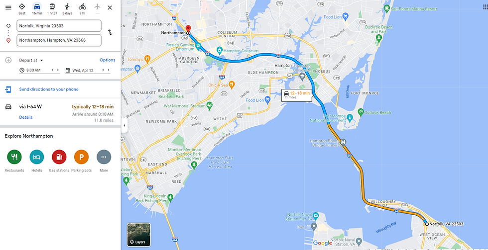
Hampton Roads Bridge-Tunnel: Hampton to/from NE Norfolk: 12 Minutes +33 Minutes in Typical Range Heavy Traffic
It becomes readily apparent that the HRBT is in need of expansion when a 12 minute drive that includes it gets expanded to as many as 45 minutes on a regular basis:

Thankfully the reverse isn't nearly as bad in the mornings with a shift to 18 minutes max typically:
The trip from NE Norfolk to Hampton grows to as much as 24 minutes in a typical afternoon, though keep in mind that the starting point is red so traffic prior to then is highly likely:

The trip from Hampton to Norfolk in the afternoon is as high as a 40-minute drive typically:

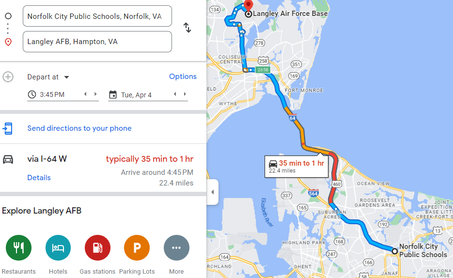
Langley AFB to/from Central Norfolk: 30 Minutes + 45 minutes in Typical Range Heavy Traffic
Langley-Norfolk Baseline: 30 minutes

Langley-Norfolk Morning Peak:

Langley-Norfolk Afternoon Peak:

Norfolk to Langley Morning Peak:

Norfolk to Langley Afternoon Peak:

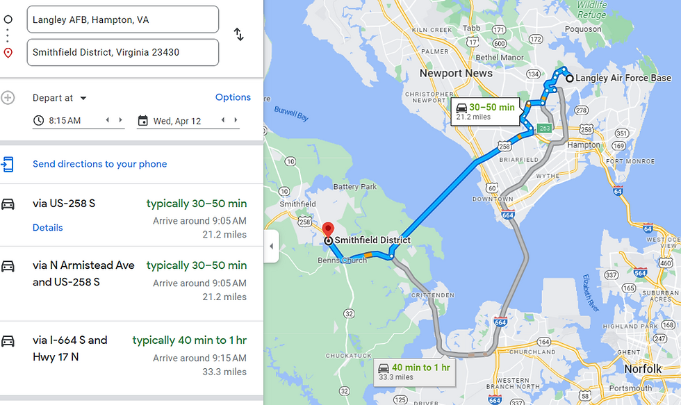
Langley AFB to/from Smithfield: 30 Minutes + 30 minutes in Typical Range Heavy Traffic
Afternoon to Smithfield: 1 hr

Morning Peak to Langley: 55 minutes

Afternoon Peak to Langley: 1 hr

Morning Peak to Smithfield: 50 Minutes
Langley AFB to/from W Chesapeake: 30 Minutes + 30 minutes in Typical Range Heavy Traffic
W Chesapeake-Langley Morning Peak: 1 hour

Langley-W Chesapeake Afternoon Peak: 1 hour

Langley - W Chesapeake Morning Peak: 45 minutes

W Chesapeake-Langley Afternoon Peak: 1 hour

Langley AFB to/from East Norfolk: 30 Minutes + 35 minutes in Typical Range Heavy Traffic
Norfolk to Langley Peak Morning: 45 minutes:

Langley to Norfolk Peak Afternoon: 1 hour

Langley to Norfolk Peak Morning: 1 hour 5 minutes:

Norfolk to Langley Peak Afternoon: 1 hour:
Langley to/from the Middle Peninsula:
Langley to Hayes in Gloucester County: 35 minutes + 25 Minutes in Typical Range Peak Afternoon Traffic
Hayes-Langley in typical peak morning traffic: 1 hr

Langley-Hayes in typical peak afternoon traffic: 1 hr

Langley-Hayes in typical peak morning traffic: 55 minues

Hayes-Langley in typical peak afternoon traffic: 1 hr

Langley to/from Barhamsville in New Kenty County
Langley to/from Barhamsville in New Kent County: 40 minutes +20 Minutes in Typical Range Peak Afternoon Traffic
Barhamsville to Langley peak morning traffic: 1 hour

Langley-Barhamsville peak afternoon: 1 hour

Langley to Barhamsville peak morning traffic: 55 minutes

Baseline 40 minutes:

Related:


Comments